
 WaypointGo · User guide
Point. Distance. Go. WaypointGo shows a live direction and straight-line distance to any place you save — offline, with no account. Here's how to use it.
WaypointGo runs on iPhone and is built to stay readable in bright sun — it runs in dark mode and portrait orientation by design. Here's what it needs to do its job:
An iPhone running iOS 17 or later.
Turned on for WaypointGo — the app asks the first time you open it.
For the best direction accuracy, a device with a magnetometer — every modern iPhone has one.
Place search is the one feature that needs a connection. Everything else works completely offline.
When you first open WaypointGo it asks to use your location — tap “Allow While Using App.” It needs your position to compute direction and distance, and it only uses location while you're using the app; it never tracks you in the background. If you decline, the app still opens but shows clear “No GPS” prompts until you enable location in Settings ▸ Privacy & Security ▸ Location Services ▸ WaypointGo.
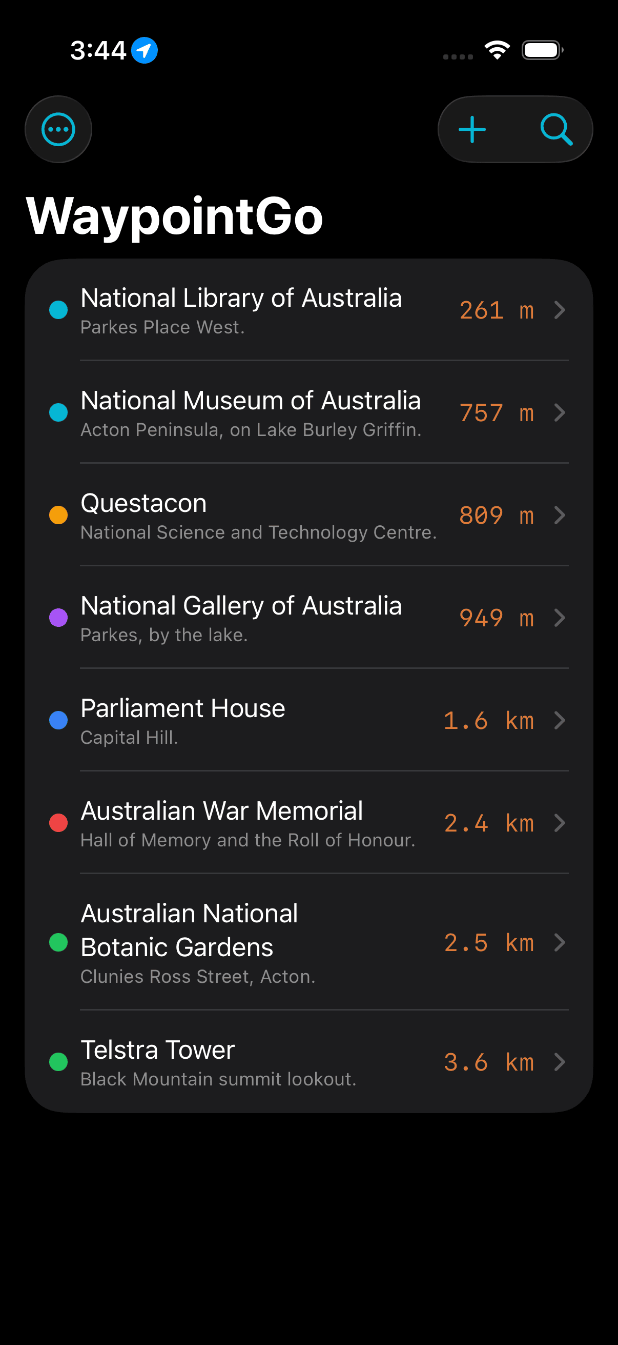
The home screen lists every saved waypoint, sorted by distance — the nearest is always on top, and the list re-sorts as you move. Each row shows a colour dot, the name and notes, and the live distance from where you are now. Before you've added anything, the screen shows a short guide to the four ways to create your first waypoint: tap +, use your location, search for a place, or import a GPX file.
Find a place by name and turn it into a waypoint — the primary action.
Create a new waypoint by location, map, or coordinates.
Import GPX, Export GPX, and Settings.
Swipe left to Edit or Delete; tap a row to start navigating.
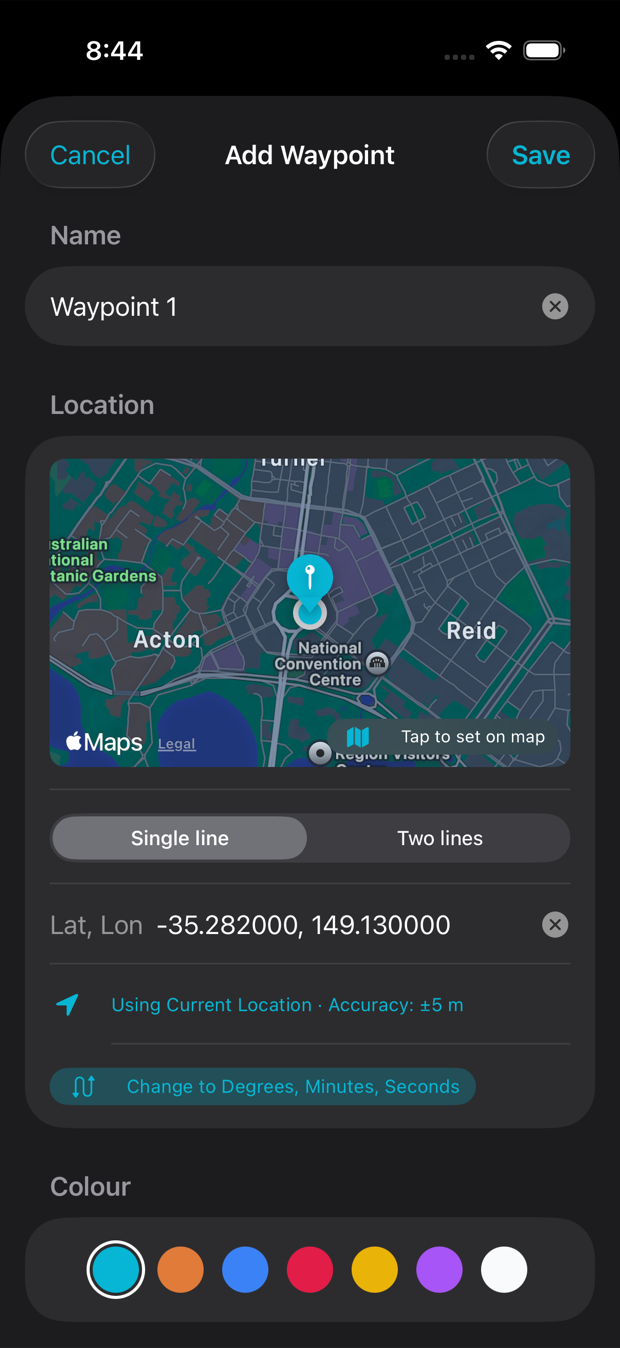
Tap +. A fresh waypoint is pre-named “Waypoint 1, 2, …” and starts following your current location. You can set its place in any of these ways:
Edit a waypoint by swiping its row left and tapping Edit (or open it from the list) — the same form opens with its current details; change anything and Save. Delete by swiping left and tapping Delete; a full swipe deletes immediately. Deleting is permanent, so export a backup first (see GPX, below) if you want to keep a copy.
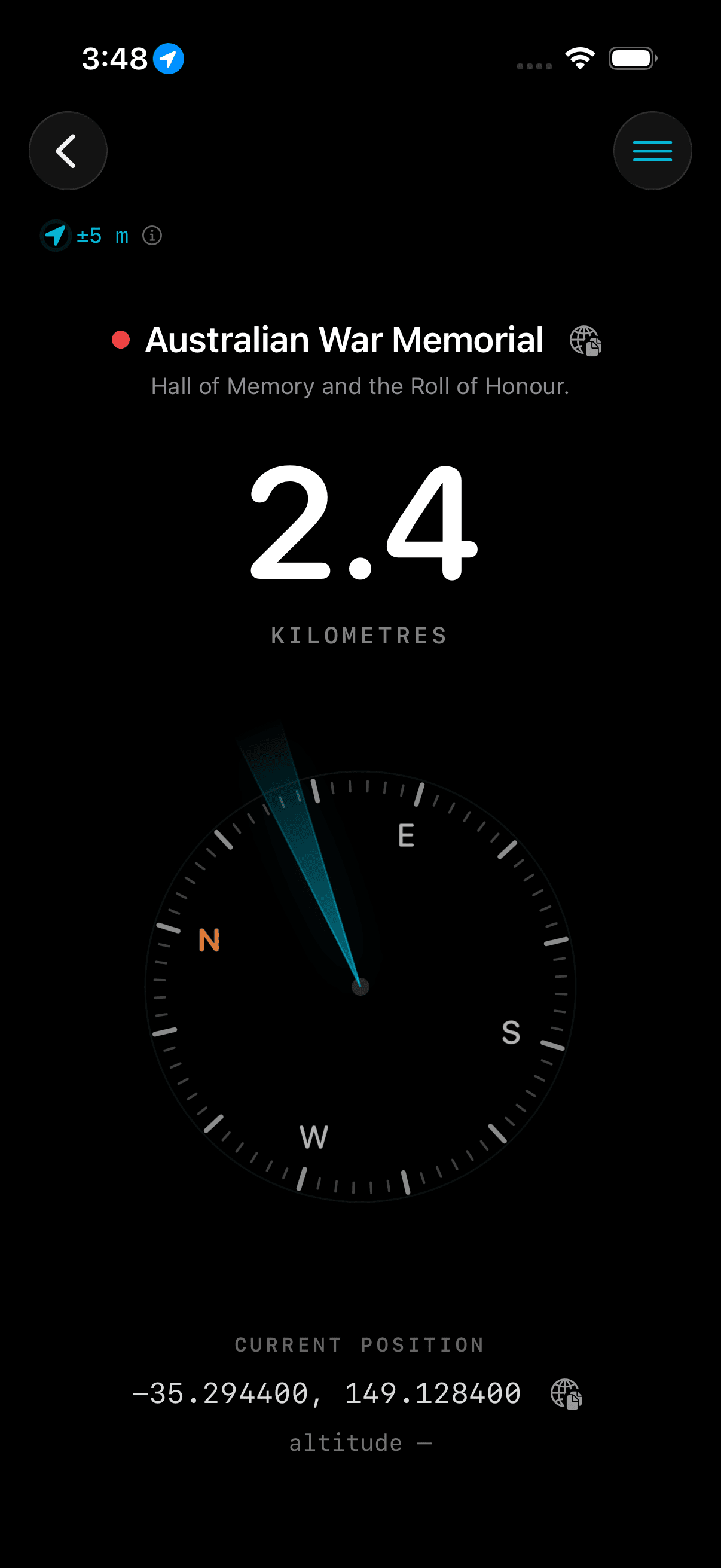
Tap a waypoint to open the navigation screen: the big number is the straight-line distance, and the compass shows a cone of accuracy pointing toward your waypoint. Hold the phone flat and turn your body until the cone points straight up — that's the way to walk, and the distance counts down as you close in. By default the screen stays awake here so it won't dim while you navigate.
Why a cone, not an arrow? A razor-sharp arrow would imply pinpoint precision GPS rarely has. The cone is wide when your fix is fresh or weak, and narrows to a sliver as it tightens. Trust a narrow cone; treat a wide one as a rough heading.
The navigation screen's ≡ menu (top right) lets you edit the waypoint, export just this waypoint as a GPX file, or Show Bearings — a readout of the exact heading to your waypoint for use with a physical compass, an ideal battery-free backup.
The bearing to dial into a baseplate compass. WaypointGo applies your local magnetic declination so it's correct wherever you are in the world.
The same direction relative to true (geographic) north, for paper maps and charts.
The local difference between magnetic and true north, shown in degrees east or west.
The magnetic figure needs a calibrated device compass with a GPS fix. If it shows —, wave the phone in a figure-8 to calibrate, then try again. Choose Show Notes from the menu to switch the readout back to the waypoint's notes.
For a bird's-eye view, tap the walking-person button (top right, left of the ≡ menu) to open full-screen Map Mode. It draws a thick cyan walking route to your waypoint that trims behind you as you go, labels the named streets along the way, and keeps the map oriented to your compass — “up” is always the way you're facing — with you centred and a heading cone showing which way you're pointing. The bottom bar shows the straight-line distance.
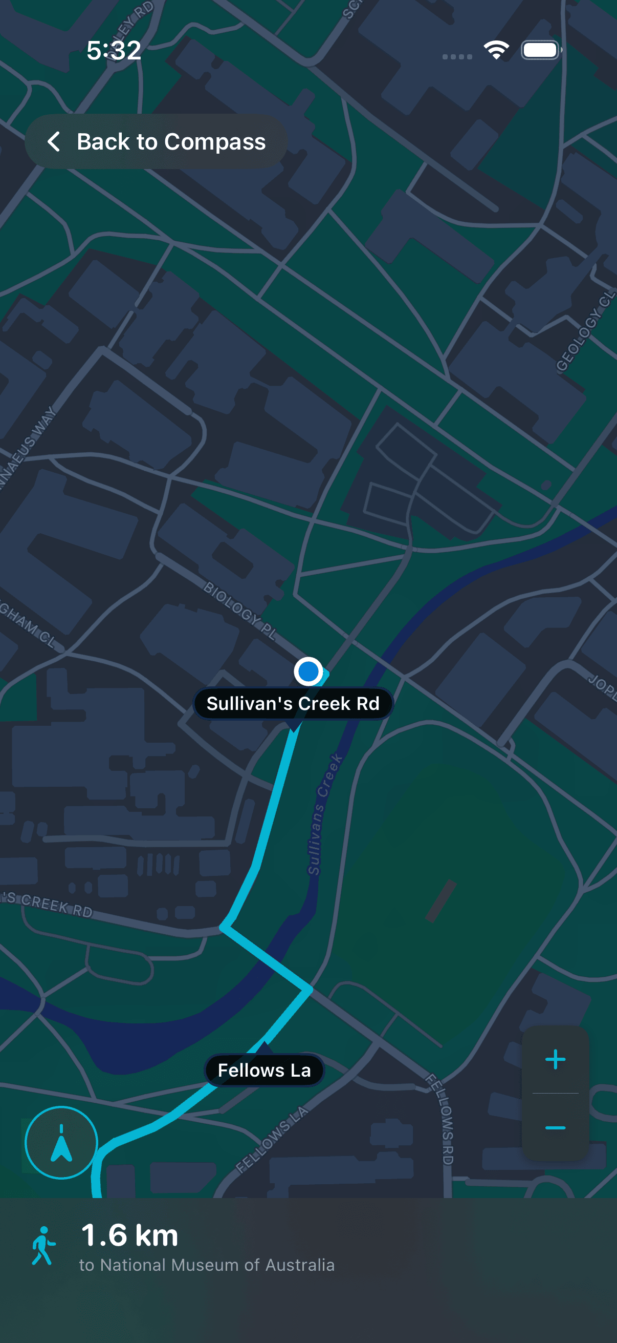
Pinch, drag, or rotate to look around (the map switches to north-up). Use + / − to zoom; tap the compass-north button (bottom left, cyan when active) to snap back to the centred, compass-oriented view.
Named roads on your route get a sign with a little arrow. Zoom out on a long route and only the major roads stay signed, to keep it readable.
Wander more than ~100 m off the route and it quietly recalculates with a brief “Re-routing…” note; stay on it and the line holds steady.
Within ~20 m of the waypoint the route clears and an “Arrived” note appears. Over water or off-road with no path, the route is hidden and the map just frames you and the waypoint together.
GPS is never perfect, so WaypointGo shows how good your fix is using one consistent colour scale across the accuracy badge, its ring, and the cone.
The accuracy badge shows your current horizontal accuracy (±X m) in the matching colour; a small accuracy ring around it pulses like a radar blip sized to your uncertainty, shrinking as the fix improves. When you first step outside, give the fix a few seconds to settle to a smaller number before you rely on the direction.
Tap the accuracy badge to open the Heading mode sheet. At the top is a shortcut to switch between Compass and GPS Course (the same setting as in Settings), and the help below updates to match — in Compass mode it covers keeping the magnetic compass honest (let the accuracy settle; keep clear of metal, magnets, and MagSafe; expect trouble near the poles); in GPS Course mode it explains that your heading comes from GPS movement, why that suits a vehicle or boat, and why you need to be moving for a heading to show.
The direction comes from your iPhone's compass (magnetometer), which is sensitive to its surroundings. If you see a “Calibrate compass” badge, wave the phone in a slow figure-8 a few times until it clears.
A red “Compass Interference Detected” label (next to the ±X m reading) means the compass is picking up magnetic interference. It keeps working — it doesn't freeze — but treat the direction with extra caution and move away from the source. The label clears on its own.
Car dashboards, metal railings, speakers, motors, and magnets all throw the compass off.
Cases with built-in magnets or metal plates can pull the compass off true. Use an official MagSafe case, or remove the case if the direction seems wrong.
Very close to the magnetic poles, or over strong local magnetic anomalies, the compass is inherently less reliable.
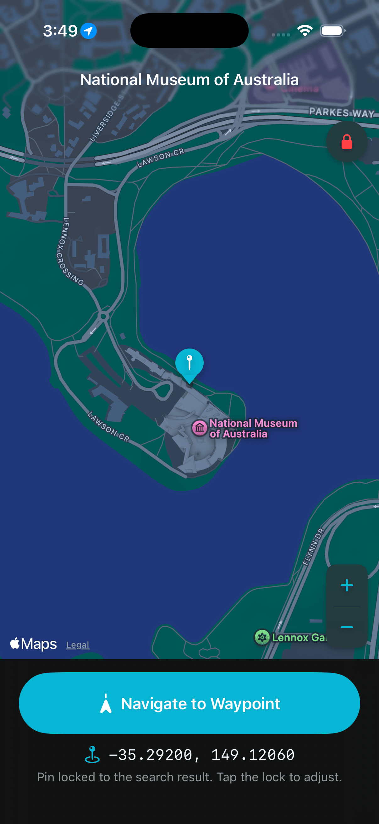
Tap the 🔍 search button and start typing — suggestions appear as you type, nearest and most relevant first. Tap one to see a map preview with live coordinates (the pin stays fixed on the place; pan and zoom to look around), then tap Navigate to Waypoint. Search is the only online feature: it needs a connection and a location fix so it can rank results near you, and shows a prompt explaining what's needed if either is missing.
WaypointGo reads and writes standard GPX 1.1 waypoint files from the ••• More menu, so you can move waypoints between apps and keep backups.
Pick a .gpx file from Files; every valid waypoint is added. Routes and tracks are ignored.
Save all your waypoints to a .gpx file via Files — back up your list to iCloud Drive or share it.
Open Settings from the ••• menu; choices save automatically.
Switch everything between metric (m/km) and imperial (ft/mi).
Compass (default) uses the iPhone's magnetometer — responsive even when standing still. GPS Course takes your direction from GPS movement instead, ideal on a boat or in a vehicle where metal interferes. In GPS Course the compass is switched off entirely, so when you stop the cone is replaced by a “start moving to display” reminder until you're moving again.
Stop the screen dimming while you're on the navigation screen.
Choose whether the Add/Edit form opens in decimal or DMS by default.
WaypointGo tells you plainly when it can't do its job because of location, instead of silently showing nothing. On the navigation screen, if location is still settling you'll see a soft “Acquiring GPS…”; if location access is off, a red “No GPS” appears with the fix — “Accept the location prompt to navigate” or “Enable Location access in Settings to navigate” — and the accuracy badge turns red. The same red prompt appears on the search screen, since it can't rank places near you without a fix.
To fix it, allow location when prompted, or choose While Using the App in Settings ▸ Privacy & Security ▸ Location Services ▸ WaypointGo. The waypoint list still works without location — it just can't show live distances or sort by nearest until a fix is available.
WaypointGo is offline-first. Once your waypoints are saved, live direction and distance, the compass and accuracy display, adding waypoints by map or coordinates, and GPX import/export all work with no signal at all — at sea, on a mountain, or in airplane mode. The only feature that needs a connection is place search. Your waypoints are stored locally on your device.
For the ultimate no-power, no-signal backup, use the Show Bearings readout to sight your waypoint on a physical baseplate compass — WaypointGo gives you the magnetic bearing with local declination already applied, so even a flat battery doesn't strand you.
WaypointGo uses your location only while you're using the app, never in the background. Your waypoints stay on your device — there's no account and no cloud sync. The app contacts the network only for place search; everything else is entirely offline.
Your iPhone has no compass heading yet. Hold the phone flat and wave it in a figure-8 to calibrate.
The compass is being disturbed. Move away from metal, magnets, and electronics, remove a magnetic case, and check True vs Magnetic north in Settings. A red “Compass Interference Detected” label warns you when this is happening — the compass keeps working, but treat the direction with extra caution until it clears.
Metal hulls, engine bays, and electrical equipment all interfere with the magnetometer. In Settings, switch Heading source to GPS Course so the cone follows your direction of travel instead. You need to be moving for GPS Course to show a heading.
There is no location fix yet. Step outside with a clear view of the sky for a few seconds. A red “No GPS” means location access is off — enable it in Settings.
You're indoors, in an urban canyon, or under heavy cover. Move to open sky and wait for the ± reading to drop toward cyan.
Search is the one online feature — it needs both a connection and a location fix. Check your signal and try a nearby landmark.
No spoken turn-by-turn. The compass shows the straight-line direction and distance to your waypoint — which way and how far — and the optional Map Mode can draw a walking route along roads and paths, but there are no voice or step-by-step prompts. This is by design.
Yes, for everything except place search. Save your waypoints and navigate fully offline.
No. The map is only used while adding or previewing a waypoint, and in Map Mode (both need a connection to load). Compass navigation itself is map-free.
There’s no account or sign-in, and no subscription — WaypointGo is a one-time paid download with unlimited waypoints and every feature unlocked.
They’re stored locally on your iPhone. There is currently no cloud sync — use Export GPX to back up or move your waypoints.
Yes — export a GPX file from the other app and use Import GPX in WaypointGo.
As accurate as your GPS fix and compass calibration allow. The cone’s width is your honest guide: narrow means confident, wide means treat it as approximate.
Adapted from the WaypointGo user manual. Features may change as the app is updated.